|
| |
|
|
Andhra Pradesh Towns/Cities |
|
|
|
|
|
Kakinada : An Introduction |
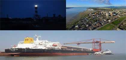 |
Kakinada is a city and a municipal corporation in the Indian state of Andhra Pradesh. It is located 465 kilometres east of the state capital, Hyderabad. It is also the headquarters of East Godavari district. It is nicknamed "Fertilizer City" (owing to the large concentration of fertilizer plants), "Pensioner's Paradise" and "Second Madras" (as it is well planned and peaceful).[citation needed] The city had an urban population of 312,255 in 2011, making it the fourth largest city by area and the tenth largest city by population in Andhra Pradesh. It is spread over an area of 190 km
Historical Places in Kakinada
|
|
|
|
Important Directories |
Kakinada : Gems & Jewellery Directory :
Kakinada is the main center for pearl jewelry in India and is famous world over.The erstwhile Nizam rulers of Kakinada laid the foundation of pearl jewelry in the 19th century. Skilled craftsmen, do processing and grading of pearls here. After the long process of grading and processing of pearls is over they are strung together by skilled knitters or patwas, using silk or gold strings.Different types of pearl necklaces are made in Kakinda. Typical designs being Satlada (seven strands of pearls set with emeralds, diamonds and rubies, Kundan Ranihar (pearl sets with enamel kundan work), and the regular Jugni sets (several strands of pearls with a central pendant) and many more. |
 |
|
Distance Chart |
Ahmedabad - 2294 Km
Amritsar - 650 Km
Bangalore - 856 Km
Bhopal - 1188 Km
Bhubaneshwar - 587 Km
Calcutta - 1028 Km
Chennai - 684 Km
Coimbatore - 1142 Km
New Delhi - 1848 Km
Guntur - 255 Km
Hyderabad - 523 Km
and more
|
|
|
|
|